Research
My work sits between computer vision and environmental science: I design models that turn
satellite imagery into ecological measurements, such as individual tree locations and species,
ecosystem types and degradation patterns.
I am driven by applications with real environmental impact, and by the technical challenges they raise:
learning from noisy labels, low-data regimes and time-series analysis.
Selected recent publications
Counting Trees from Satellite Imagery with Noisy Supervision
Dimitri Gominski, Maurice Mugabowindekwe, Qiue Xu, Xiaowei Tong, Martin Brandt, Hieu Le, Rasmus Fensholt, Dimitris Samaras, Loic Landrieu
ECCV, 2026
arXiv /
paper
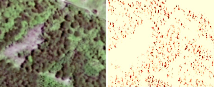
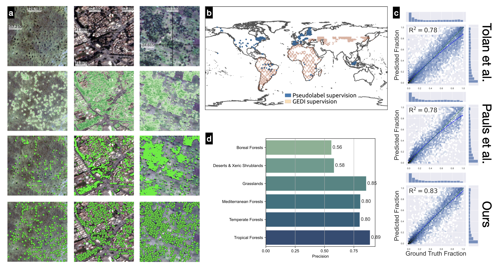
We frame tree counting as spatial density matching with unbalanced optimal transport. This handles both isolated trees and dense canopies, and a self-correction step uses transport residuals to clean up noisy labels during training.
Uncertainty-aware Tree Height Change Regression
Max Gaber, Dimitri Gominski, Jaime C. Revenga, Stefan Oehmcke, Rasmus Fensholt, Martin Brandt
ECCV, 2026
arXiv /
paper
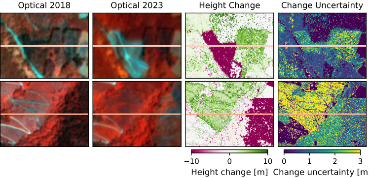
Canopy change is usually treated as binary change detection. We release the Canopy Height Change dataset, with 3 m continuous height differences and per-pixel uncertainty over 10,598 km² of Spain, and introduce uncertainty-aware change regression with matching metrics.
Align and Segment: Unsupervised Learning for Building Segmentation from Misaligned Labels
Venkanna Babu Guthula, Oswin Krause, Dimitri Gominski, Hui Zhang, Johan Mottelson, Ankit Kariryaa, Nico Lang, Christian Igel
ECCV, 2026
arXiv /
paper
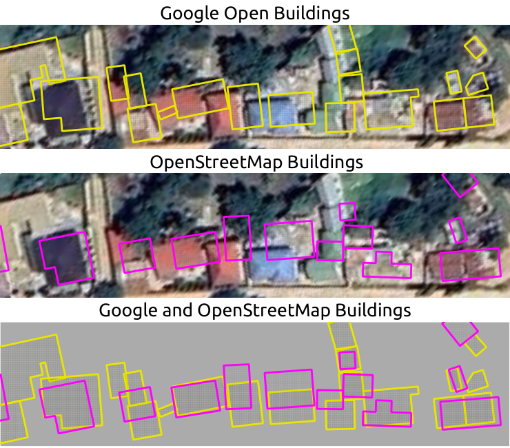
Labels from sources like OpenStreetMap rarely line up with the imagery. A spatial transformer learns to realign the labels while the segmentation network trains, with a self-supervised loss that stops the network from learning the misalignment.
Highly Fragmented European Wetlands with Uneven Restoration Needs
Gyula Mate Kovács, Xiaoye Tong, Dimitri Gominski, Stefan Oehmcke, Stéphanie Horion, Christin Abel, Eva Ivits, et al., Rasmus Fensholt
Nature, 2026
paper
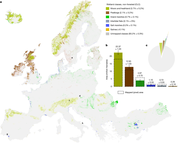
A 10 m map of six semi-natural wetland types and land-use disturbance across 38 European countries. It shows that wetlands are highly fragmented, that about 20% are affected by human activity, and where restoration under the EU Nature Restoration Law matters most.
Trees as Gaussians: Large-Scale Individual Tree Mapping
Dimitri Gominski, Martin Brandt, Xiaoye Tong, Siyu Liu, Maurice Mugabowindekwe, Sizhuo Li, Florian Reiner, Andrew Davies, Rasmus Fensholt
Journal of Remote Sensing, 2026
paper
A global model that detects large individual trees in 3 m PlanetScope imagery. Crowns are modeled as scalable Gaussian kernels, giving both tree centers and tree cover maps. Training uses billions of points extracted automatically from airborne LiDAR, so trees are found both inside and outside forests.
A Remote Sensing-Based Solution for National Scale Tree Counting
Maurice Mugabowindekwe, Dimitri Gominski, Florian Reiner, Xiaoye Tong, Philippe Ciais, et al., Rasmus Fensholt, Martin Brandt
Journal of Remote Sensing, 2026
paper
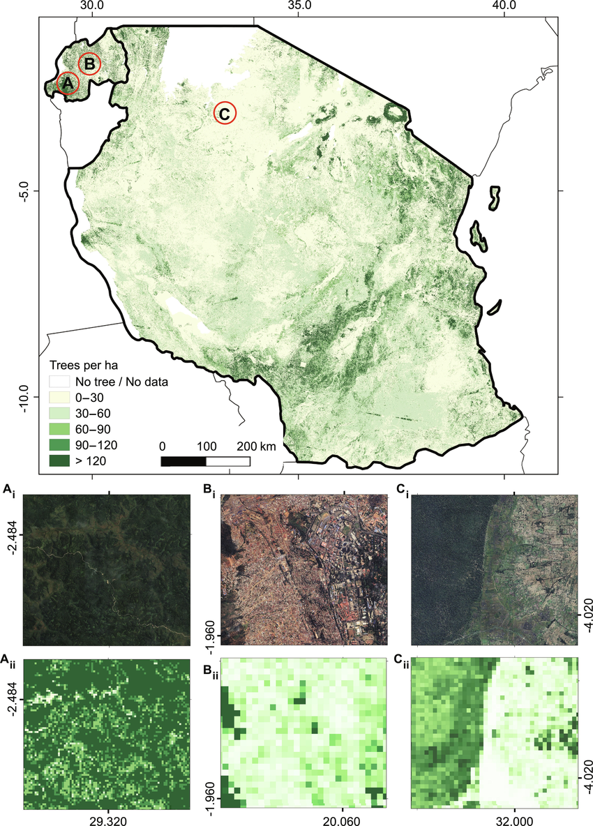
Counting trees nationally across Rwanda and Tanzania from freely available PlanetScope, Sentinel-1 and Sentinel-2 data. We estimate about 5.2 billion trees, roughly half of them outside areas mapped as "tree cover".
Severe Decline in Large Farmland Trees in India over the Past Decade
Martin Brandt, Dimitri Gominski, Florian Reiner, Ankit Kariryaa, Venkanna Babu Guthula, Philippe Ciais, Xiaoye Tong, Wenmin Zhang, Dhanapal Govindarajulu, Daniel Ortiz-Gonzalo, Rasmus Fensholt
Nature Sustainability, 2024
paper
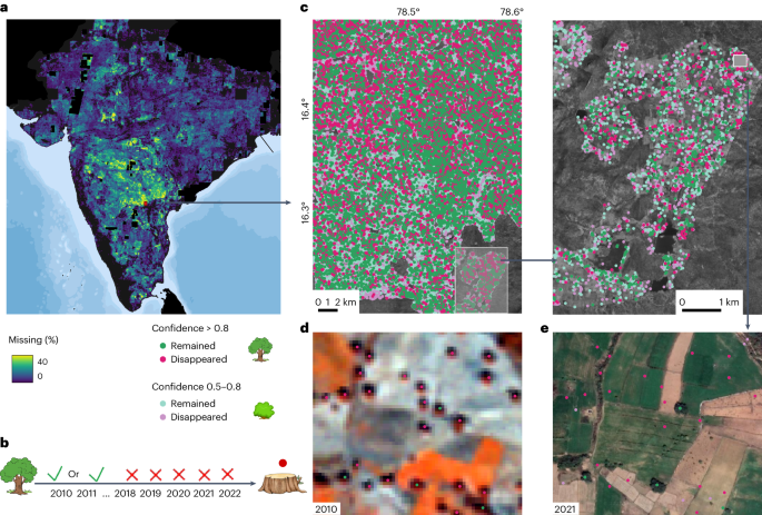
We map 0.6 billion individual farmland trees across India and track them over a decade. About 11% of large trees mapped in 2010/2011 were gone by 2018, and more than 5 million more disappeared between 2018 and 2022.
Get Your Embedding Space in Order: Domain-Adaptive Regression for Forest Monitoring
Sizhuo Li, Dimitri Gominski, Martin Brandt, Xiaoye Tong, Philippe Ciais
ECCV, 2024
project page /
arXiv /
paper
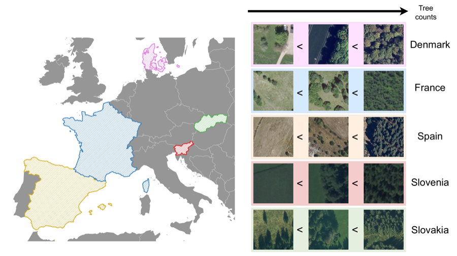
DRIFT is a dataset of aerial and satellite imagery from five countries with three forest regression tasks, built to study domain shift. We propose manifold diffusion for regression, a strong baseline for adapting at test time with few labels.
Mining Field Data for Tree Species Recognition at Scale
Dimitri Gominski, Daniel Ortiz-Gonzalo, Martin Brandt, Maurice Mugabowindekwe, Rasmus Fensholt
ECCV Workshops, 2024
arXiv /
paper
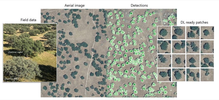
Species labels for individual trees are automatically mined from public forest inventories by matching field plots with trees detected in aerial imagery, with almost no human work. Adding noisy and even unlabeled samples helps, which points toward species mapping at scale.
Trees on Smallholder Farms and Forest Restoration Are Critical for Rwanda to Achieve Net Zero Emissions
Maurice Mugabowindekwe, Martin Brandt, Athanase Mukuralinda, Philippe Ciais, Florian Reiner, et al., Dimitri Gominski, et al., Rasmus Fensholt
Communications Earth & Environment, 2024
paper
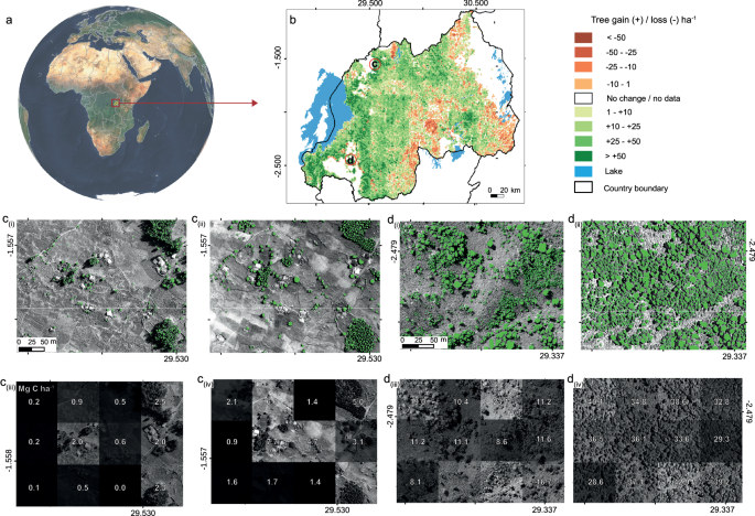
Carbon stocks of every tree in Rwanda in 2008 and 2019. Smallholder farmers planted about 50 million new trees, and agroforestry and forest restoration together could offset a substantial share of national emissions.
Cross-dataset Learning for Generalizable Land Use Scene Classification
Dimitri Gominski, Valérie Gouet-Brunet, Liming Chen
CVPR Workshops (EarthVision), 2022
Best Student Paper Award
paper /
code
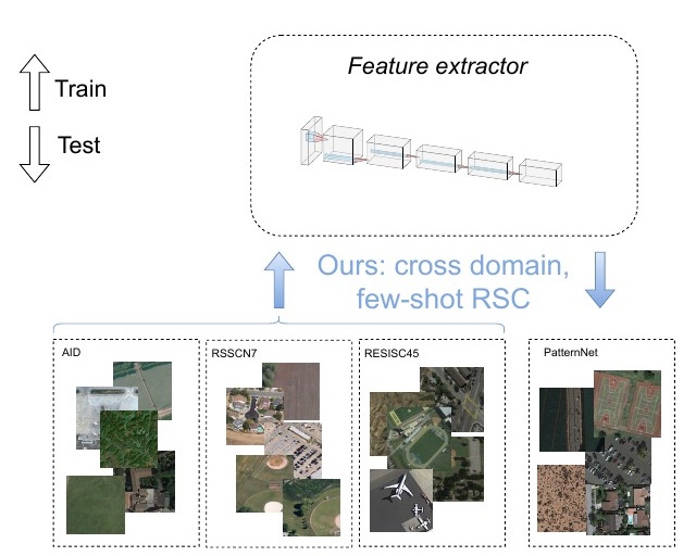
A retrieval-inspired framework that trains on several land-use datasets at once and classifies scenes from unseen datasets and unseen classes with only a few reference images, going beyond standard few-shot and cross-domain settings.